*** MWD tool can now work with ArcGIS 9.2 and 9.3***
Development Team:
Multi-Watershed Delineation (MWD) is a standalone windows program that uses ArcObjects and TauDEM (http://hydrology.usu.edu/ taudem/) functionality to derive watershed polygons, river networks, and watershed attributes for multiple sites across large geographic extents. The MWD software also provides a tool to summarize several physical and environmental characteristics of the delineated watersheds.
The MWD tool is designed to create a shapefile containing watershed boundaries for multiple stream sites within a large region and provide data characterizing those watersheds. If the user only needs to delineate and calculate stream watershed attributes for small numbers of watersheds, it may be easier to use other software such as the interactive TauDEM software (http://hydrology.usu.edu/taudem/).
This tool is developed for users with intermediate GIS skills, and we assume users have an understanding of how to:
- Obtain and manage spatial data with ArcCatalog
- Analyze and project GIS data sets with ArcToolbox
- Select and edit features and join data in ArcMap
Other Information:
1. The MWD tool uses ArcObjects functions that are part of ArcGIS from Environmental Systems Research Institute, Inc. (ESRI).
2. The MWD tool is available for Windows operating systems that support ArcGIS for Windows.
3. The MWD tool has been tested with ArcGIS 9.0 and 9.1 and requires either ArcView, ArcEditor or ArcInfo licences. The MWD Tool source code is available under an open source GNU General Public License.
Distribution
Copyright (C) 2006 Kiran Chinnayakanahalli, Utah State University
This program is free software; you can redistribute it and/or modify it under the terms of the GNU General Public License version 2, 1991 as published by the Free Software Foundation.
This program is distributed in the hope that it will be useful, but WITHOUT ANY WARRANTY; without even the implied warranty of MERCHANTABILITY or FITNESS FOR A PARTICULAR PURPOSE. See the GNU General Public License for more details.
The distribution for MWD Tool for ArcGIS 9.x comprises the following:
MWD Setup.exe (8 Mb) An install shield setup file that installs the MWD tool.
aml.zip (6 KB) Contains aml files (agree.aml and hydrogrid.aml) required for preprocessing of data. These amls were written by Ryan Hill. Please contact him at ryanhill@cc.usu.edu if you have any questions about the amls.
MWDManual.pdf.
(4 MB) User's manual in Adobe Acrobat format. To read this
you need the free
Adobe Acrobat (TM) Reader.
example.zip. (1.5 MB) A zip file containing a
small test example as follows:
Shape files:
- Outlets.shp. A point file containing sites for which watersheds will be delineated.
- HUC.shp. A polygon shapefile that serves as Medium Hydrologic Units (MHU-see manual for definition).
Raster files:
- test_dem. Raster digital elevation model (DEM)
- test_fill. Sink filled DEM
- test_fd8. Flow direction grid
- test_fa. Flow accumulation grid
- test_str. Stream grid
The above data set can be used to get some experience on the data formats and outputs created by the MWD tool. See Getting started section for using this data to delineate watersheds.
Practice_sites.csv ( 4 KB) Data for the more extended realistic example given in the users manual (sections 2.1, 2.2 and 2.3).
Source Code ( 17 MB) Contains the MWD dll code (C++) and MWD EXE code(VB).
Version
This release is Version 1.0, the first release.
Publications
Chinnayakanahalli, K., C. Kroeber, R. Hill, J. Olson, D. G. Tarboton and C. Hawkins, (2006), "Manual for Regional Watershed Analysis Using the Multi-Watershed Delineation Tool," Utah State University. (Adobe PDF 4 MB).
Chinnayakanahalli, K., D. G. Tarboton, J. Olson, R. Hill and C. Kroeber, (2006), "A Tool to Delineate Watersheds and River Networks for Multiple Sites Spread over Large Digital Elevation Models," Hydrology Days, Colorado State University, Fort Collins. (POSTER)
Acknowledgements
• This tool and associated processes were developed with support from the U.S. EPA Science to Achieve Results (STAR) Program Grant no. R- 82863701.
• Testing by Seth Flanigan
Support
There is no formal ongoing support for this freely distributed open source software. However, we are interested in feedback. If you find errors, have suggestions, or are interested in any later versions contact:
Getting started
This section give the steps for using the MWD tool with the small test example (example.zip) data set. Typically the MWD tool would be used with much larger data sets because its purpose is to delineate watersheds over large regions that may be too large to process in a GIS at once. For this example the required preprocessing described in the manual (Chapter 2) has already been done. The steps involved in running the MWD tool are given in Figure 1.
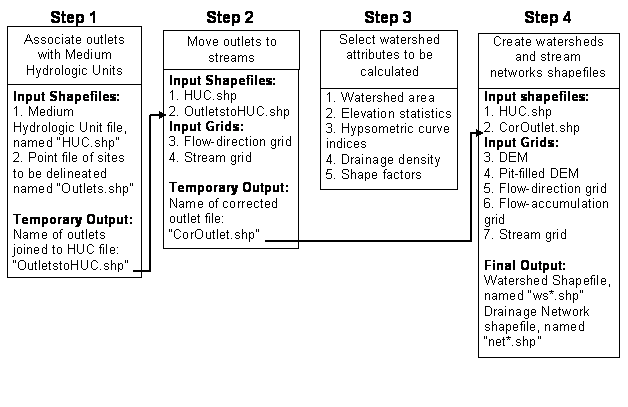
Figure 1: MWD tool processing steps.
To start, download and unzip the example data set (example.zip) to a working directory (For example "E:\work"). This will create another folder called "example " in the working folder. If you open the E:\work\example in ArCatalog, it should contain the following input files:
Shape files:
- Outlets.shp. A point file containing sites for which watersheds will be delineated.
- HUC.shp. A polygon shapefile that serves as Medium Hydrologic Units (MHU) (see manual for definition).
Raster files:
- test_dem. Raster digital elevation model (DEM)
- test_fill. Sink filled DEM
- test_fd8. Flow direction grid
- test_fa. Flow accumulation grid
- test_str. Stream grid
Figure 2 shows the DEM with the MHU and the outlets. All other grids are of the same extent as DEM.
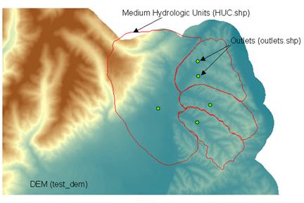
Figure 2: The example data set (DEM raster with MHU and outlets).
If you have already installed the MWD tool, open the program using Start> Multi Watershed Delineation>MWD Tool. Click on the browse button of the "Base DEM" and point to the test_dem file. The paths and the interface should look like Figure 3.
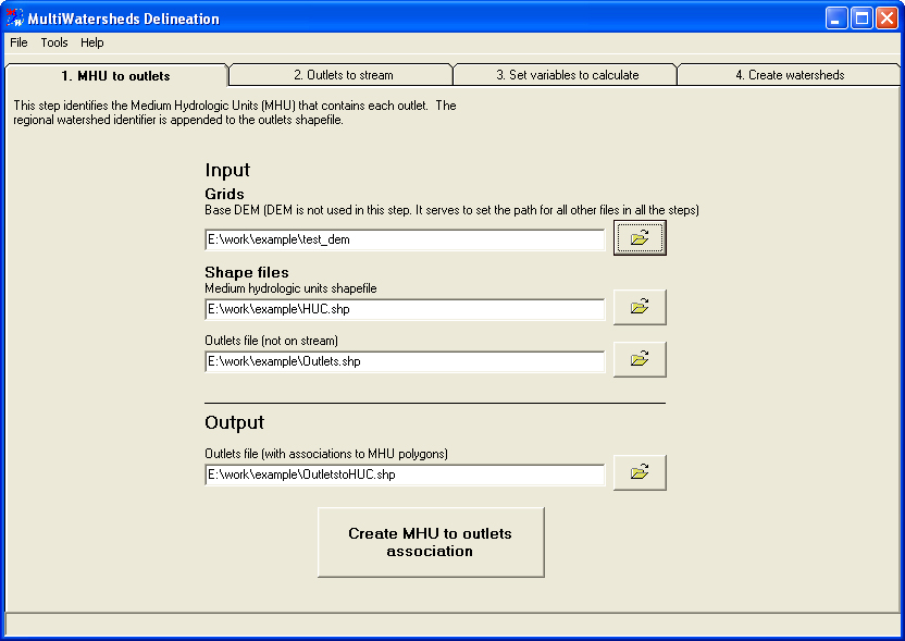
Figure 3: Step 1-Creating the association between the outlets and the MHU.
Click on "Create MHU to outlets association" button. This will create a new point shapefile called "OutletstoHUC.shp" (default name). This shapefile is visually similar to the outlets.shp, but has information about its association with the MHU-polygon shapefile. The successful completion of this step will automatically take the user to Step 2. Figure 4 shows the interface of the second step in the MWD tool.
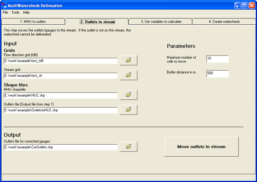
Figure 4: Step 2- Moving outlets to the stream.
Click on "Move outlets to stream" button. This will start the process of rolling down the outlets to the nearest stream (see section 2.3b of the manual for learning more about this step). The parameter values can be left at their default values (refer the manual for their definitions). The completion of this step will take the user to the third step shown in Figure 5. Choose the variables you desire to be computed and say next which will take the user to the fourth step of the MWD tool (Figure 6).
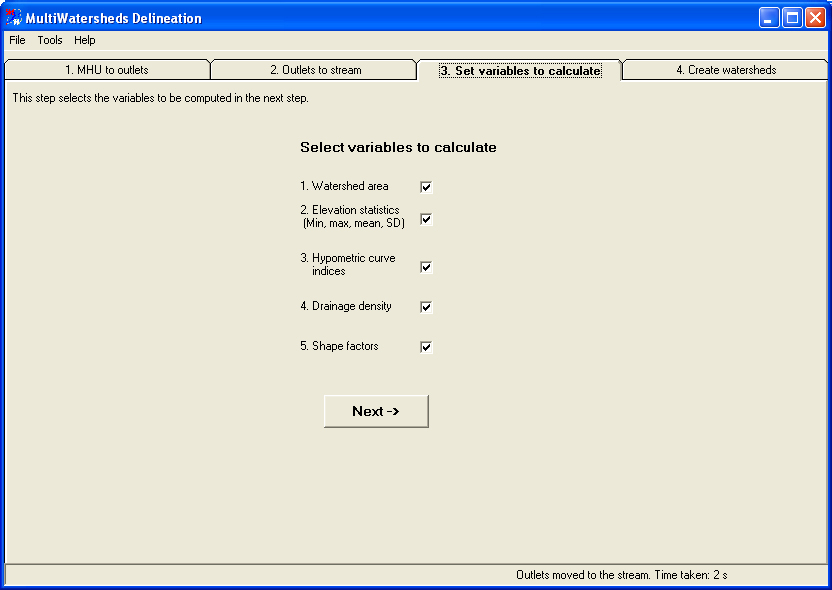
Figure 5: Step 3-Selection of variables
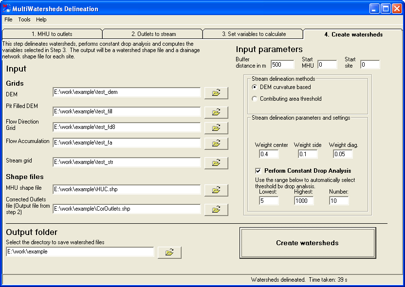
Figure 6: Step 4-Watershed delineation.
Click "Create watersheds" button. This will start the watershed delineation process for the outlets. The user is advised to refer to the manual for the definitions of the various terms, before changing any parameters. The default values work for most of the cases. The successful execution of this step will create two shapefiles for each of the outlets, a watershed polygon shapefile (ws*.shp) and stream-network line shapefile (net*.shp). In this example it will create a total of ten files (Figure 7). A log file called "Donelog.txt" is created which tells the user about the details of the execution. The variables selected in Step 3 are computed and stored in the attribute table of each polygon shape file. The attribute table shown in Figure 7 is obtained by merging all the watershed polygon files created by the MWD tool.
NOTE: If you are running this program for the second time, make sure the folder does not contain any output files from the previous runs (example ws*.shp and net*.shp).
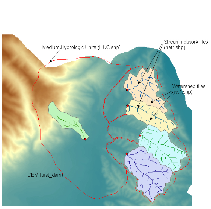
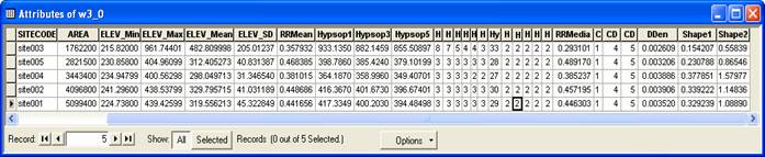
Figure 7: The watershed and network files-output from the MWD tool.
-----The End-----