 |
|
|
|
|
|
|
|
|
|
|
|
|
|
|
|
|
|
|
|
|
|
|
|
|
|
|
|
|
|
|
|
|
|
|
|
|
|
|
|
|
|
|
|
|
|
|
|
|
|
|
|
|
|
|
|
|
|
|
|
|
|
|
|
|
|
|
|
|
|
|
|
|
|
|
|
|
|
|
|
|
|
|
|
|
|
|
|
|
|
|
|
|
|
|
|
|
|
|
|
|
|
|
|
|
|
|
|
|
|
|
|
|
|
|
|
|
|
|
|
|
|
|
|
|
|
|
|
|
|
|
|
|
|
|
|
|
|
|
|
|
|
This web site is
my fall semester 1999 term project of the CEE 6930 GIS in Water
Resources, Water Division, Civil and Environmental Engineering,
Engineering Department, Utah State University, U.S.A. This class is
the distance learning class from the class CE 394K.3 GIS in Water
Resources.
|
|
|
| |
|
|
|
|
|
 |
|
|
|
|
|
|
|
|
|
Water-Surface
Evaporation in Reservoir
By
Vitoon Thititanapak
CEE
6930 GIS in Water Resources
December,
1999
|
|
|
| |
|
|
|
|
|
 |
|
|
|
|
|
|
|
|
|
Outline
Class and term paper
Background
Objective
Concept and Conceptual Map
- Theory Study
- Data
Collection and study area
- Data Development
Develop the water-surface area
Calculation of the evaporation in reservoir
Conclusion
Reference
PowerPoint Presentation
|
|
|
| |
|
|
|
|
|
|
|
|
|
Class and
term paper
This term paper is a part of the course CEE 6930: GIS in
water resources. GIS is stand for Geographic Information System.
This class is an ONLINE class for Utah State University (USU)
students on the Fall Semester 1999. The classes lecture live at the
University of Texas at Austin and the lectures are posted on the web
site for watching after. Dr. David R. Maidment is the instructor and
Dr. David G. Tarboton is the USU coordinator.
|
|
|
| |
|
|
|
|
|
|
|
|
|
Background
According to Dingman in
Physical
Hydrology (1993), he
stated that evaporation is an important factor of reservoir in
determining the yield of water supply and the reservoir
construction. The 62% of precipitation that falling to the land is
evapotranspiration, or it is about 72,000 cubic Kilometers per year.
In this amount, 3% is the evaporation from open-water surface and it
is about 2,160 cubic Kilometers per year. The other 97% is the
evapotranspiration that is the water evaporates from soil-surface
and the plant transparency. In the reservoir operation, evaporation
is one of the factors in calculating the loss of water from
reservoir. Sometimes it is called "evaporation loss."
GIS is a computer technology that can be applied to
present the geospatial data or the data information in graphic
features. People can better understand the data presentations in the
graphic feature than in the table or the list forms. The development
of computer technology is advancing very quickly and it has
abilities to support the GIS concept. Nowadays GIS is used to
present the information in many fields such as civil, water
resources, environment, agriculture, geology, hydrology, business,
city and urban planning and etc. The concept of GIS is to import the
data from many sources in several forms such as maps, images,
tables, pictures, and digital products, and then overlay them
together to create a new graphic and do calculation to solve the
interested problems. The GIS data is available from several sources
such as the U.S. Department of transportation, the U.S. Census
Bureau, the U.S. Geology Survey (USGS), the Environmental Protection
Agency (EPA), etc. The users also can create the data by themselves.
They can download some data from the World Wild Web in Internet or
load files data from some recorded devices such as CD. Some data are
free of charge but some have to pay for.
|
|
|
| |
|
|
|
|
|
|
|
Objective
My purposes for this
term paper are:
To study the effect of evaporation upon the reservoir
water-surface.
To apply GIS techniques to find the evaporation from
reservoir.
|
|
|
| |
|
|
|
|
|
|
|
|
|
Concept
and Conceptual Maps
The concept of this
paper is using GIS data to develop the water-surface areas of the
reservoir at every 1-meter storage level depth, and then calculates
the evaporation loss. The annual reservoir operation plan can be
produced by using the monthly mean reservoir-storage elevation to
estimate the monthly evaporation losses. The short-term reservoir
operation plan can be carried out by using the current reservoir
storage elevation to predict the evaporation of the next month.
|
|
|
| |
|
|
|
|
|
|
|
|
|
|
|
|
|
|
 |
|
|
|
|
|
|
|
|
|
|
|
|
|
|
|
|
|
|
|
|
|
|
|
|
|
|
|
|
|
|
|
|
|
|
|
|
|
|
|
|
|
|
|
 |
|
|
|
|
|
|
|
|
 |
|
|
|
|
|
|
|
|
|
|
|
|
|
|
|
|
|
|
|
|
|
|
|
|
|
|
|
|
|
|
|
|
*Estimated monthly release demands are estimated by using the mean monthly demands
data of all of the water-use activities, such as evaporation loss,
seepage loss, irrigation demand, domestic-use demand, transportation
demand, flood control, land improvement demand, etc.
The concept of the term paper
processes is divided into three main sections.
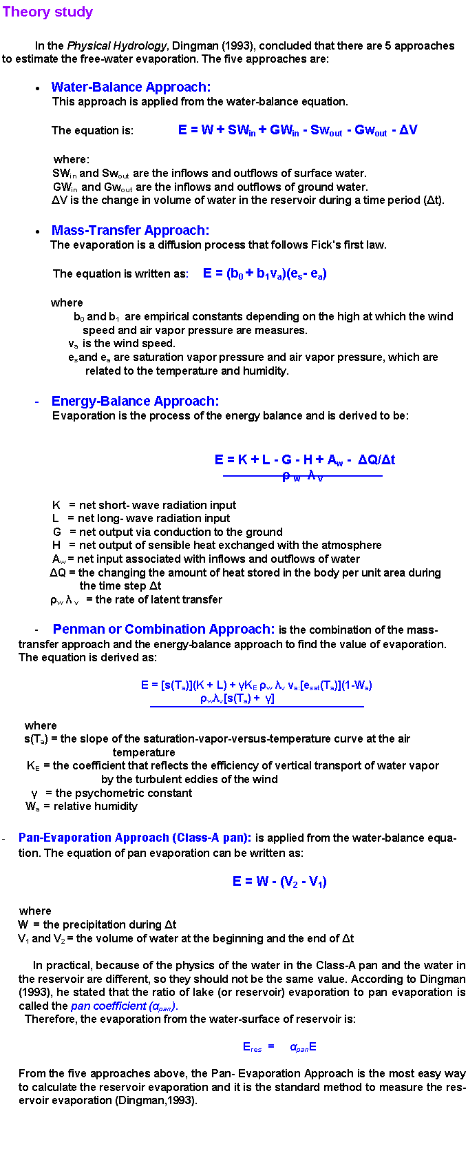
Section one, Theory Study: is to study the physics of evaporation in Hydrologic
Cycle and how to measure the evaporation upon the water-surface
areas of the reservoir.
Section two, Data Collection: is to collect data and select the study
areas.
Section three, Data Development: is to import the necessary data into a GIS program to
create the water-surface area of the reservoir, then calculate the
volume of evaporation.
|
|
|
| |
|
|
|
|
|
|
|
|
|
|
 |
|
|
|
|
|
|
|
|
|
|
|
|
|
 |
|
|
|
|
|
|
|
|
|
|
|
|
|
|
|
|
|
|
|
|
 |
|
|
|
|
|
|
|
|
|
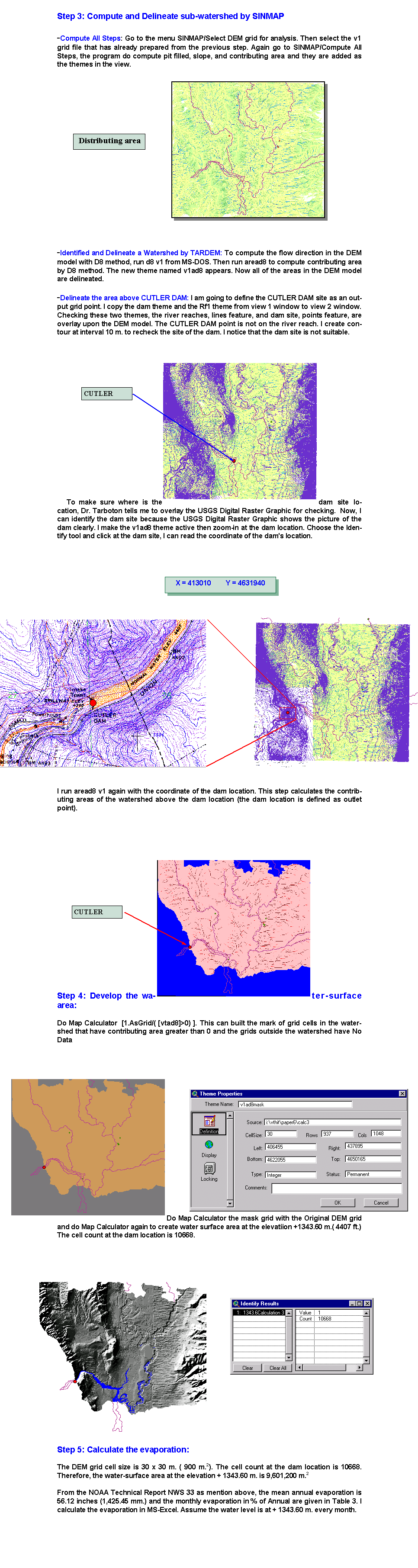
Data
Collection and study area
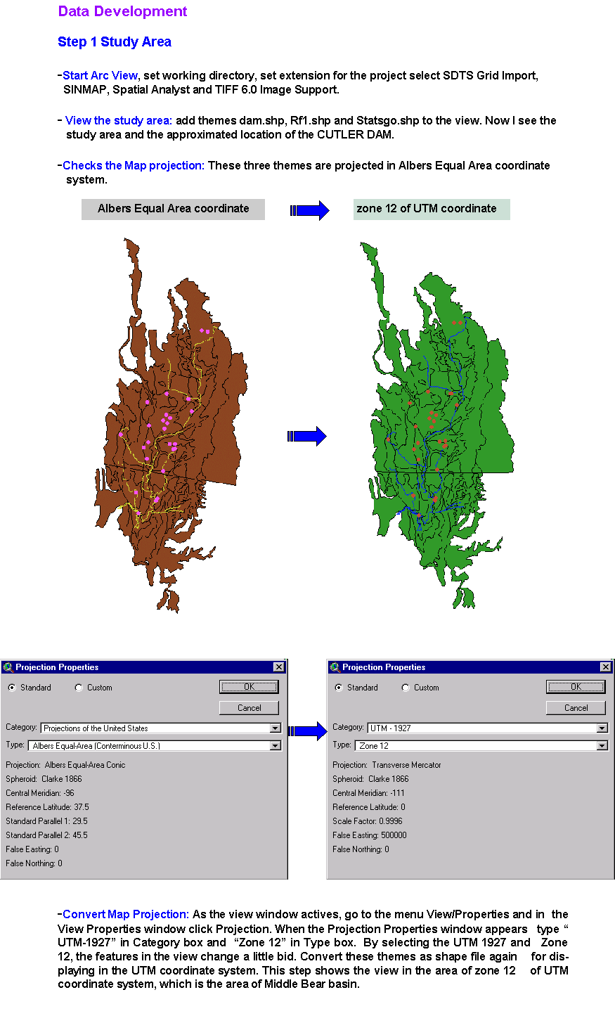
When I started to look at GIS data, first I studied from the
lectures and exercise handouts. I found that my paper could due with
the exercise 3: Delineating the watersheds and stream network and
the exercise 6: Hydrologic Properties of the Landscape. So I knew
that I needed to use DEM grid files, Rf1 shape file, dam site
location, HUC shape file, evaporation file and Class-A pan
coefficient. I then worked on Internet and searched for several web
sites. I had to look at the large - scale map (1: 250,000) from EPA
web site and USGS web site to select a study area. I looked for all
necessary data I needed for the study area. Unfortunately, I could
not find every data I needed. I could find DEM, Rf1, Dam site
location. Therefore, I decided to use the evaporation data and
Class-A pan coefficient from the NOAA Technical Report NWS 33.
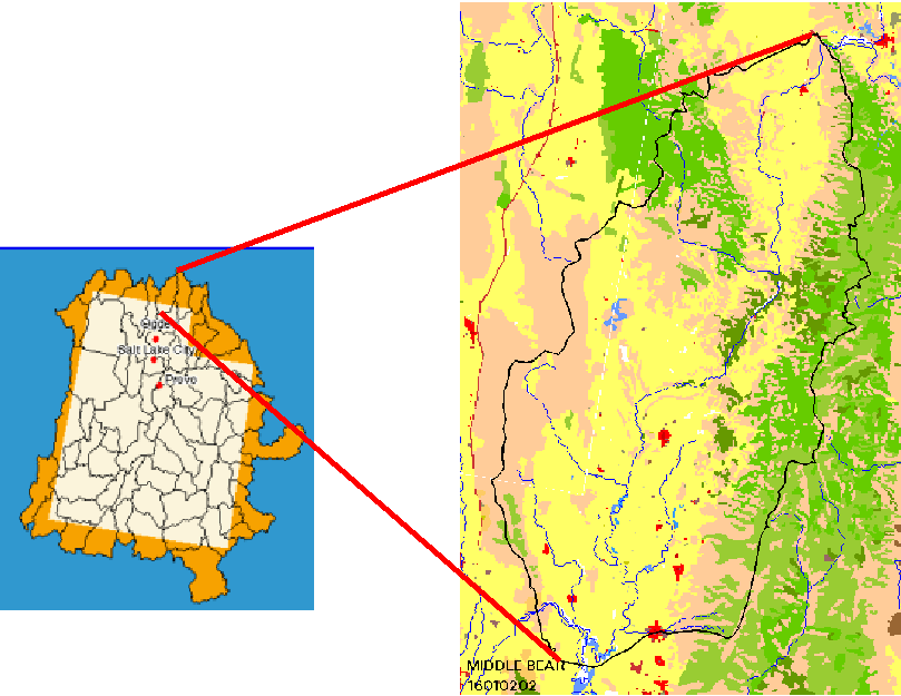
To view the study area, I looked in the
web site of EPA, http://www.epa.gov/ost/BASIN/STATES/UT/ and clicked
mouth at the Middle Bear basin then downloaded core data. I added
dam.shp and Rf1.shp to ArcView and opened the themes. I saw the
locations of the dams in the Middle Bear basin and I selected Cutler
dam as my study area.
Dam Name
CUTLER
County BOXER
ELDER ( Box Elder County)
River
BEAR RIVER
Dam height 109
ft. or 33.23 m.
Longitude -
111.950000
Latitude
41.816667
Normal Storage Elevation +
4407 ft. or + 1343.60 m.
Normal Storage
Capacity 13,200 Acre-ft. or 16. 236
M. m.3
|
|
|
| |
|
|
|
|
|
 |
|
|
|
|
|
|
|
|
|
Data
Collection
When I decided to use Cutler Dam as my study
area, I collected all data from several sources.
- DEM from
USGS http://edcwww.cr.usgs.gov/doc/edchome/ndcdb/ndcdb.html
RF1 from
EPA
http://www.epa.gov/OST/BASINS/HUCS/16010202/
Dam site from EPA http://www.epa.gov/OST/BASINS/HUCS/16010202/
and from GIS DATA
DEPOT http://www.gisdatadepot.com/
Pan - evaporation data from
NOAA Technical
Report NWS 33
Evaporation Atlas for the Contiguous 48 United States, Washington,
D.C., June 1982.
Table 3: Adjusted mean monthly Class A pan evaporation for
selection stations, 1956-70
Map 4 : Map of coefficients to
convert Class A pan evaporation to free water surface
evaporation, May - October.
|
|
|
| |
|
|
|
|
|
 |
|
|
|
|
|
 |
|
|
|
|
|
|
|
|
|
|
|
|
|
 |
|
|
|
|
 |
|
|
|
 |
|
|
|
|
|
|
|
|
|
|
|
 |
|
|
|
|
|
|
|
|
|
|
|
 |
|
|
|
|
|
|
|
|
 |
|
|
|
|
|
 |
|
|
|
|
|
 |
|
|
|
|
|
 |
|
|
|
|
|
 |
|
|
|
|
|
 |
|
|
|
|
|
|
|
|
|
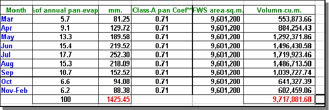
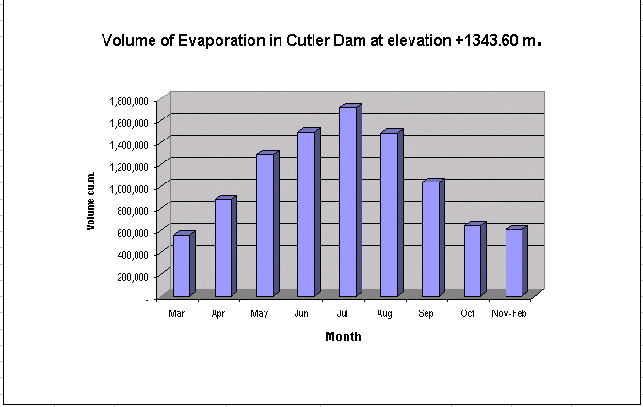
Conclusion
The result can achieve the
objectives of the term paper. I mean that the methods and the
processes can be applied to solve the similar problems. The result
may not complete. That is because the DEM grid file is processed
after the CUTLER Dam has been constructed and already has water
storage. Therefore, the contours below the water surface can not be
developed. It is assumed that the water level in the reservoir of
the CUTLER DAM is at the same level every month. The evaporation
from the water-surface of the CUTLER DAM is about 9.717 Million
cubic meters per year. The area of the water-surface at elevation +
1343.60 m. is about 9.6 square kilometers.
The method using in this paper should be
developed in the step of TARDEM. TARDEM should be able to work with
ArcView directly without the needs of MS-DOS processing.
I think that, this method can be applied
to find the inundated areas at the interested elevation for
estimating the reservoir area in the feasibility study of a new dam
project.
The future work that I want to
do is to complete my objectives of this paper. I think when the dam
was designed, the water-surface areas at every water levels of the
reservoir were measured and usually were plot as a Water-Surface
versus Elevation Curve. I want to use this data to create the
water-surface area in ArcView to solve the DEM data problem as I
mention above.
|
|
|
| |
|
|
|
|
|
|
|
|
|
Farnsworth R.K., Thompson E.S. and Peck E.L., Evaporation
Atlas for the Contiguous 48 United States,
NOAA Technical Report
NWS 33, June 1982, p
1-24
Dingman S.L., Evapotranspiration in
the Physical
Hydrology, 1993, p
257-271
|
|
|
| |
|
|
|
|
|
|
|