
By Paul Wirth
CEE 6440 GIS in Watershed
Experience Gained from Project
Introduction
Over the past few years there has
been an increasing interest for many people that want to bring data collected
over
To address these
concerns and others David Chandler [1] from the Department of Plants, Soils,
and Biometeorology at Utah State University (USU) held a meeting
At the meeting I took on the task of explaining to the attendees that I would like to collect the data and research that existed and turn that data over to Hadi Jaafer [2], a Ph.D Student in Irrigation Engineering at USU, to put it into the computer for public interactive viewing on a Internet Map Server (IMS) for ArcView maps (ArcIMS).
Data
Collecting
During the meeting
it seemed that many people were excited about sharing data and ideas about
On
The first meeting
was with Richard Toth [3] from the Department of Forest Resources at USU who
expressed a great deal of interest in the
I met next with
Wayne Wurtsbaugh [4], from the Department of Fisheries and Wildlife at USU who
said that he had a lot of limnolgical data for the
Professor Phaedra Budy [5], from the Department of Fisheries
and Wildlife at USU, had a lot of information. She is doing a lot of research
on the fish health of the Watersheds of Cache Valley. This research is ongoing
and because she is new at
I was getting
pretty discouraged by this time because I hadn’t been able to collect any
substantial amount of useable data for my project so I started contacting other
people that might be able to help me. It occurred to me that that maybe the
person involved in gathering the GIS data for
One of the initial
appointments that were quite useful was with Karen Hanna [6] from the Landscape
and Environmental Planning Department at USU. We talked for a few minutes. She
said that she had a lot of coverages, shape files and digital images on the
Later that day I
met with Nancy Mesner [7] from the College of Natural Resources (USU). She was
not at the meeting so I filled her in on what I wanted to accomplish with my
project. She was very helpful and was able to supply me with data from the
Little Bear River and the rest of the Bear River Watershed. In the process of
our conversation she was also able to supply me with the CD of the
My next contact
was with Barbara Daniels [8] from a private organization called Monitoring Utah
Wetlands. Her organization monitors wildlife, vegetation and water quality from
the
I met with Mr. Nicholson [9], from the Utah Department of Wildlife Resources, and he was able to supply me with digital images and points where the data was collected in GIS form. This will make it easier to combine the two pieces of data onto my database in the CEE lab.
The last person I
talked to about gathering data was Chris Mcginty[10], a Masters Student from
the Geography and Earth Resources Department at USU that had some information
on
Experience Gained from
this Project
In the ever continuing effort of collecting data for this project I encountered many obstacles that needed to be overcome in order to make the data useable in the CEE lab that uses the Windows operating system. The many problems encountered were: 1) reading files that couldn’t be read in the CEE lab, 2) transferring data from a UNIX system to a Windows based operating system, and 3) copying data.
The first thing that I did before I started collecting data was to set up a file transfer protocol (FTP) account with Professor Tarboton [11] in the Civil and Environmental Engineering Department at USU. He explained it to me but I really didn’t catch on until I got some data emailed to me at home in Quatro Pro format. I couldn’t open it at home so I copied it to an ftp file in my account at school. At school the GCL didn’t have Quatro Pro so I had to download the ftp Quatro Pro file onto a Natural Resource lab computer, open it as a Quatro Pro file, save it as a Excel file and copy it to my ftp file so I could use it in the CEE lab.
The next problem that I encountered was how to get UNIX operating system files into readable Windows files. I tried to transfer files at first by downloading the UNIX files onto a disk and then just putting the disk into the GCL computers and uploading. Needless to say it didn’t work. I asked some friends and they said that there is program called Secure Shell that will do that. A friend of mine let me borrow the program so I could transfer files that I needed for my project from the UNIX system to the Windows system in the GCL. The secure shell program made it possible to transfer data with ease from the UNIX operating system to the Windows operating system with no big loss of data.
Now that transferring data could be done with ease with almost any kind of data I start downloading and copying so I could have the data on my I drive in the GCL. As I finished doing this for a considerable amount of data I went into Arc/GIS to import it and play with it a little. Much to my surprise some coverages, shapefiles and images didn’t copy over. I kept getting errors when I tried to open them. After much suffering I started downloading or copying one file at a time and opening them in Arc/GIS to see if it worked. It seems that when I was downloading multiple files sometimes they got corrupted and I couldn’t open them so I downloaded one file at a time which gave me a readable file almost 100% of the time in Arc/GIS.
After sorting all the data that was going to use I had to convert every thing I had into shapefiles so that the Internet Map Server could read the files. This was a long and tedious process that took many hours but was a time saver for my partner Hadi Jaafer. He could now import the data in shapefiles into the IMS and start to create interactive maps on the internet.
Not all the data
was very useful and in fact some of the data was damaged and couldn’t be
opened. In those cases I didn’t consider fixing the problem because it wasn’t
my data. For example the data on the CD for the
Another problem that arose was that data was not gathered with GPS points. This can best be illustrated by the image below (Figure 1).
Figure 1.
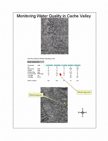
The problem with the data in Figure 1 is the water quality data was not Georeferenced with points on the ground where it was collected. The points were just placed on the ArcView map that had predefined coordinates so when I changed the map projections the points ended up in some other place on the map or even disappeared.
A common problem with the data I collected is that many features were not labeled like in the figure below (Figure 2). In this case the name of the Watershed and the area of the Watershed were missing. This created a problem that could remedied with some time, but that wasn’t part of my project.
Figure 2.
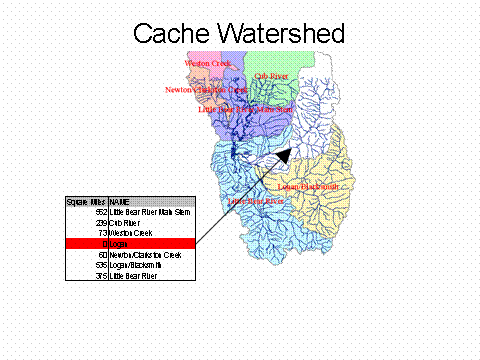
The last problem that I would like to talk about happened in the Little Bear River Watershed and was similar to the same one we encountered with Logan River Watershed. A piece of that Watershed got left out because the DEM data said that the water flowed to the Cub River Watershed in the North located in Figure 2 above.
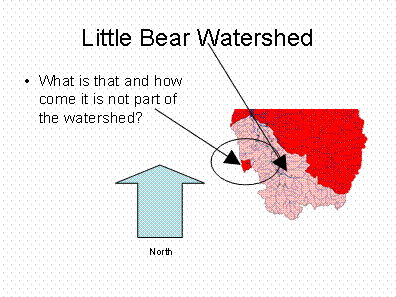
A research project that was done on the Little Bear River Watershed didn’t include a small little area on the bottom of the map (Figure 3). Now Unlike the Logan River Watershed this little area circled below is hard to access and see if the DEM is correct or not. This clarification should be done at a future date by verifying this area on the ground as to which way it flows.
Figure 3.
This project is so huge and the amount of data so enormous that I have just scratched the surface. Not all the data was useful and some of it didn’t make any sense. Only a small portion of it was passed on to Mr. Jaafer so he could put it on IMS. There is still a lot of data out there that could be collected and formed into something that made some sense if somebody wanted to make this into a Masters Project.
- Chandler, David. Personal contact.
- Jaafer, Hadi. Personal contact and Project partner. Fall Semester 2001.
- Toth, Richard. Personal interview.
- Wurtsbaugh, Wayne. Personal interview.
- Phaedra, Budy. Personal interview.
- Hanna, Karen. Personal interview.
- Mesner, Nancy. Personal interview.
- Daniels, Barbara. Telephone interview.
- Nicholson, Brain. Personal interview.
- Mcginty, Chris. Personal interview.
- Tarboton, David. Personal contact.