Building a Stream Network for the
Using ArcHydro
By: Dennis Russell
Background
The
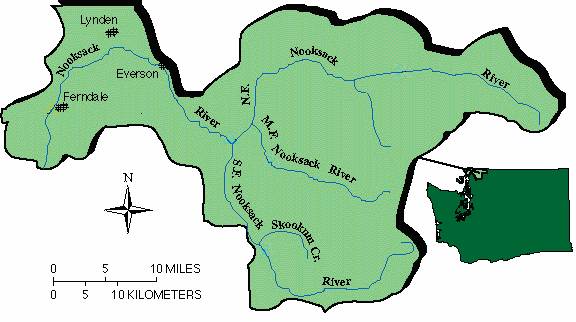
Fig. 1 Nooksack Area (USGS, 2001)
The
Researchers at
Goals
I was able to extract my project from the larger study being
done by
Data Used
The data used in this project included EPA River Reach Files (RF3), National Hydrography Data Sets (NHD), HUC watersheds, Digital Raster Graphic (DRG) (7.5’ quads) and time series data for multiple river gauges. I was able to obtain the NHD, HUC, and time series data from the World Wide Web, and Connely Baldwin supplied the Stream gage shape file, DRG’s and RF3 data.
Data Preparation
The first thing that I needed to do was to find the data that I actually needed, and to prepare it to be put in the ArcHydro model. First I found the Nooksack watershed polygon from an NHD coverage, which I could use to select streams, stream gages and water bodies within the drainage area.
The next and probably most difficult step was to edit the streams to remove loops and improve connectivity. Shown in the diagram below is an example of loops that I located with the Network Analyst tool “Find Loops.” I had to manually remove all of the loops in the network, while still trying to keep the stream in the best location. Also in the stream network there were unconnected stream segments, these segments also had to be connected as part of the editing process.
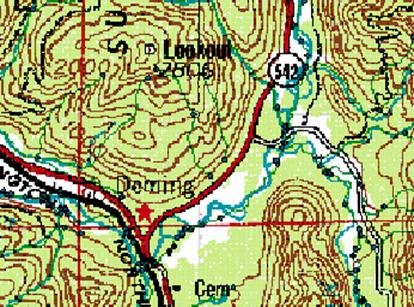
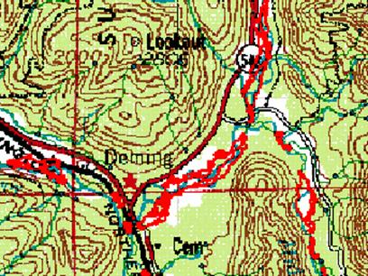

Fig 2. Editing Loops
ArcHydro
Once the editing of the stream network was complete, I could
then follow the process shown below. 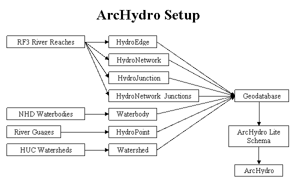
Fig 3. ArcHydro Setup
First I imported the data that was collected and edited, into a Personal Geodatabase with the following structure.
HydroEdge shape file containing streams
HydroJucntion shape file containing nodes of the stream network
HydroNetwork stream network created from HydroEdge and HydroJunction
HydroNetwork_Juctions netowork nodes created with HydroNetwork
HydroPoint shape file containing river gauge information
Waterbody shape file containing waterbodies in the drainage area
Watershed shape file containing watersheds
Once the Personal Geodatabase was created the next step was to apply the ArcHydro Lite Schema, which remodeled my geodatabase to the one that is shown below in Figure 4. Applying the schema automatically created data fields in each of the feature classes within the geodatabase and built relationships between the feature classes.
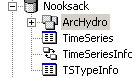
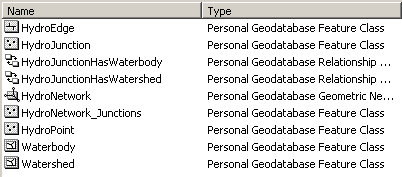
Fig 4. Nooksack
Personal Geodatabase
Once the schema was applied I was ready to use the ArcHydro tools. First I applied the Assign Hydro ID tool to assign a unique ID to all of the reaches, nodes, watersheds, water bodies and stream gauges. Next the Length Downstream for Edges and Length Downstream for Nodes were used to calculate and store lengths downstream for stream reaches and nodes respectively. Then I applied the Flow Direction tool to store the flow direction for each river reach as an attribute in the HydroEdge shape file. Next I applied the Find Next Downstream Junction tool which finds the next downstream node ID and stores it in the attribute table to establish connectivity. The final tool that I applied was the Store Area Outlets, this tool stores the area of the watershed as an attribute at the most downstream node in the watershed.
Time
Series Data
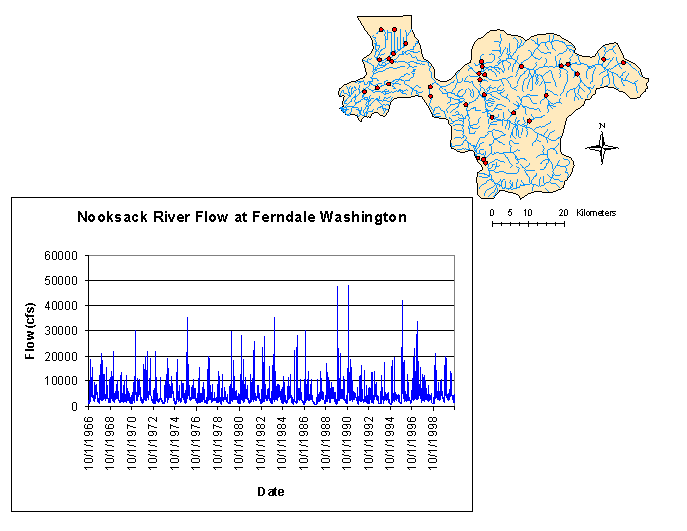
The next thing that I wanted to do in creating the model was to import and attach time series data to the network. At first I tried using a cool NWIS tool that I found linked to Dr. David Maidment’s website. It used the gage ID from the gage feature class to build a URL and automatically download gage data, but I was unsuccessful in getting it to work properly. I was able to down load time series data from the USGS website and create a table in Excel that was imported into ArcMap as a database; however I couldn’t attached the time series data to the river network because of my unfamiliarity with how ArcHydro handles the data. Shown below is a time series graph that I produced from time series data for USGS gage # 12213100 at Ferndale Washington.
![]()
Fig 5. Stream Flow at
Comparisons
As part of this project I wanted to make three comparisons. The first was to compare the RF3 stream to Quad maps. As you can see from the figure below, the RF3 streams lie fairly close to the streams that are shown on the quad map but dose contain loops in the streams as well as a few unconnected stream segments.
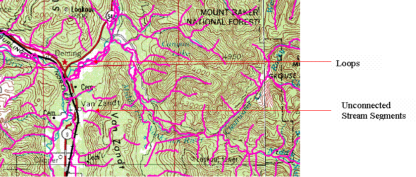
Fig 6. RF3 Streams
The NHD streams were again fairly close to those on the quad map. The NHD had quite a few loops and many unconnected stream segments.
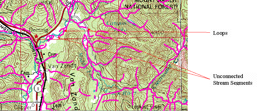
Fig 7. NHD Streams
Finally in comparing the RF3 Data to the NHD data I found that the RF3 data was better defined, showing more detail and better correspondence to the quad maps. I also found that although the RF3 had more loops it had a lot better connectivity. As can be seen in figure 8 below the NHD (in red) has poor connectivity when compared with the RF3 (shown in blue).
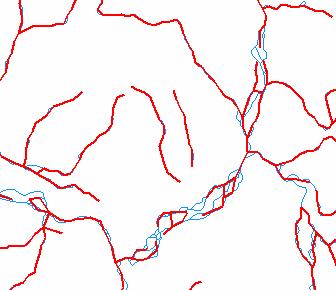
Fig 8. NHD and RF3
Conclusions
Although I wasn’t able to do everything that I wanted with this project, I felt that I gained a greater knowledge and appreciation for ArcHydro and GIS. From this project I found that ArcHydro can be a very powerful tool in creating a model of a river basin by adding attributes and building relationships between many physical attributes. I also found that RF3 data is better for building the network because of its better connectivity and detail.
Acknowledgements
I would like to acknowledge two people for their help with my project. First, Connely Baldwin for giving me with the idea for the project and providing the data also Dr. Tarboton for helping me work through my GIS problems.
References
Saraeva, Ekaterina. (2000) Application of GIS for
Calculation of Travel Times for the
Available: http://moose.cee.usu.edu/giswr/archive00/termpapers/saraeva.htm (
USGS.