|
|
Select image to the left to view an animated population
density simulation |
|
|
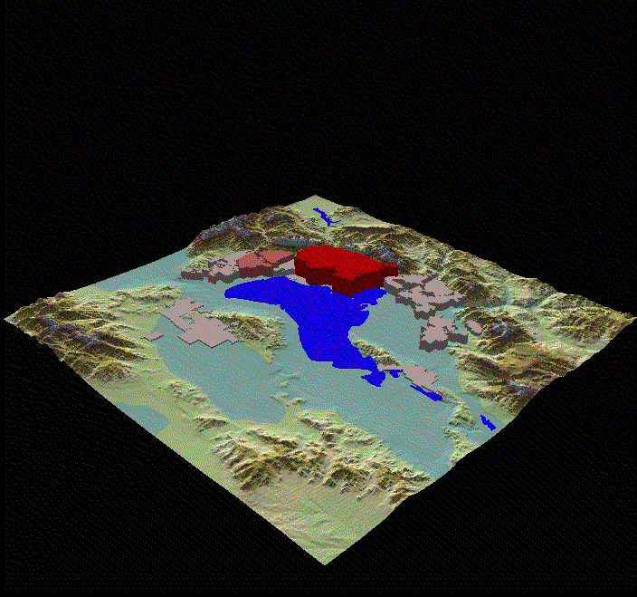
Select image to the left to view an animated city
sprawl simulation |
Of Utah Valley
And its Effects on Water Use
Modeling
In compliance with
requirement
For CEE 6930, USU
Instructor: David Tarboton
By
Dallas Wall
November 27, 2000
|
INDEX
OF PROJECT
IntroductionThe Central Utah Project (CUP) is the largest and most costly transbasin diversion in Utah. The basic goal of the project is to make available the state’s primary developable water supply to the population centers of the state. The primary user of water in the state is agriculture with municipal and industrial (M&I) water use accounting for only 17% (“Utah’s Water Resources, Planning for the Future”). However, as the Greater Wasatch Front area grows in population the current sources of water are being developed and used. Recent demand for municipal water has looked to the CUP as a possible source. If the CUP water can be made available to the population centers along the Wasatch Front, the problem remains as to how the water would be distributed to each municipality. The most obvious solution to water appropriation in the M&I water use category hinges on population demand. Though this utilitarian solution seems simple the process of estimating where most of the people will be in the future is often difficult. The state of Utah currently tracks and projects population data through the Governor’s Office of Planning and Budget (GOPB). Projecting population figures into the distant future creates a literal “Pandora’s Box” scenario. The current method of population growth estimates assumes that population centers of today will be the centers of tomorrow. Though this approach works well in short time increments it tends to overlook the spatial requirements and political agendas of municipal growth. If water supply is awarded to cities that do not meet their population projections in the future, the planners may have inadvertently crowned a water-czar in the future market. Spatial requirements of cities are very important to cities along the Wasatch Front because of the large number of individual cities that border one another within the region. As cities become bounded on all sides there ability to grow will be greatly decreased. “Vertical” population growth is often cited as the solution to bounded cities. However, will some cites grow vertically while the surrounding communities still enjoy a rural lifestyle? A check of population estimates with a spatial component would enable planners and modelers to compare densities of cities within the area. This project attempts to illustrate current population projections within the spatial domain of GIS, and proposes options to model municipal water use based on spatial growth. Utah Valley was chosen as the subject area because of its key location to the CUP. Though this process has been limited to only a few cities the approach could be applied to every city within the state that can provide accurate boundary descriptions. Procedure General Process Schematic
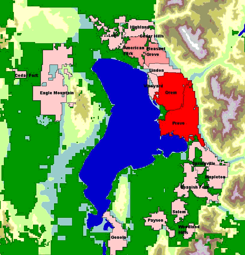
Figure 1 General Process Schematic Identify Growth Areas ArcView was used to identify which of the surrounding undeveloped lands were most likely to be victims of urban sprawl. A theme was created showing the privately owned lands within the study area. See Figure 2 below.
Figure 2 Privately Owned Lands in Utah Valley The source of this coverage is Utah States Automated
Geographic Resource Center (AGRC)
and the coverage is entitled “Land Status/Administration/Ownership”. Determine Max Growth Extents The Distance tool that is supplied with the 3D Analyst was modified to not only create a distance grid for each of the cities but also create the allocation grid for each of the cities. This allowed the identification of the maximum growth region for each city to be based on the proximity of the private lands in the area. Create Growth Bands The stepwise fashion of this model incorporates a simplistic growth sequence by moving the city boundaries out when a density limit is met. The distance grid was reclassified using the slice option (again required modifying the existing tools) to create growth rings for each city. Fourteen incremental slices was assumed reasonable to maintain an appropriate size for each growth increment and also to insure that the maximum limit would not be exceeded. See Figure 3 below for growth rings.
Figure 3 Growth Rings for Communities The growth grid was then converted multiple shape files that identified the city boundaries at each incremental growth stage. The geographic databases that correspond to city boundaries were combined to create an input table for the growth algorithm. Each shape had a unique identifier to track the growth stage and the city boundary. A view of the corresponding shape files and a portion of the geographic database are shown in Figure 4.
Figure 4 Growth Areas and Geo-database Table Determine Growth Pattern A chart of the population versus density for each of the study cities is provided below. The exponential curve fit supplied by Excel is defined by Equation A. However, Equation A returns negative values for populations below 1169 (when solving for density). For this reason Equation A’ was developed and used in the analysis. Oddly, the R^2 term for Equation A’ indicates that its curve more wholly represents the data. Equation A’ was used in the growth algorithm to identify when the density of a city requires the area growth sequence to occur (enlarging the area reduces the density and allows the population to rise).
Figure 5 Derivation of Growth Pattern Sequence (Equation A’ was used) Growth Algorithm The growth algorithm was developed in Excel VBA. The specific algorithm flow chart is illustrated in Figure 6. The growth algorithm basically requires the geo-database input generated in ArcView and a table of population projections for the given cities. As the population growth of a city is tracked the density of that city is compared with the values in equation A’. If the result triggers an area growth sequence to occur, the city is allowed to increase its area by one growth ring. The density is then rechecked. To insure that all of the growth does not occur in one year a safety stop was programmed into the algorithm that only allows three growth rings to occur in one year. This process was added to allow cities to gradually grow into the curve delineated by equation A’.
Figure 6 Growth Algorithm Schematic Export Result Table to GIS The output table generated in Excel was then saved as a DBF file type and imported into ArcView as a table. This table was then linked to each of the growth stage themes mentioned earlier. The city boundaries for each year were identified and separate themes were created on five-year increments (from 2000-2050). The maximum projected build out is illustrated in Figure 7. Please note the high-density population in the Orem and Provo (Figures shown are close to twice the current density in these communities).
Figure 7 2050 Population Densities for Utah Valley ResultsUrban sprawl is a concern that faces many different planning groups within our society today. The process presented herein, questions the integrity of assuming population growth will seek location rather than space. Will bounded cities grow vertically while surrounding communities still enjoy a rural lifestyle? One iteration through the process above constitutes an illustration of predictive modeling. With further iterations, which implement local planning goals, this model can become more normative in nature. Local planning goals may be based on resource demands, which could also be mapped by the iterative process of this model. For example if higher population densities lead to lower infrastructure costs but higher densities increase community service costs, then what is an optimal density for a given population. The primary focus of this project is to illustrate the need of spatial analysis when projecting population numbers into the future. The proceeding subsections illustrate the growth process of population within Utah Valley, and also suggest how this population growth modeling may effect predicting municipal water use. Spatial Analysis for Population Growth By comparing the size and location of cities in Figures 2 and 7 it can be seen that some of the cities are expected to grow in area. However, the cities of the largest population growth (Provo and Orem) grew very little before their sprawl was curtailed by surrounding obstacles. In order to achieve the population ascribed to them these cities must become denser. However, a large amount of private land could be put into development west of Spanish Fork, Salem and Payson. Under current conditions it is more likely that the ascribed population of Orem and Provo will be evenly spread out to communities north and south. However the current population projections cannot anticipate this spread because of the lack of spatial modeling. Population density graphs for three categories of community growth are shown below in Figures 8, 9, and 10 respectively. The first category is the cities that have reached their spatial maximum boundary and are forced to meet population projections by growing more densely. Figure 9 illustrates the communities that were able to instigate growth as the population increased thus allowing the density to follow the function expressed in Equation A’. The jogs in their density identify the act of incrementing land to the overall city size. Finally, Figure 10 illustrates the cities that currently have sufficient lands to meet all of the projected population growth. Certainly this category of community is a prime candidate for overflow population from the communities listed in Figure 8.
Figure 8 Densely Populated Communities
Figure 9 Communities with Area to Meet Population Demand
Figure 10 Communities with Overflow Capabilities Municipal Water Use ModelingRecent efforts to project water use in the future have been based primarily on projected population numbers. Current use rates are applied to future population projections and factors are applied to account for conservation or other foreseeable effects to the current use rate. Past studies by the Division of Water resources has shown that historical water use trends have changed very little over time. The prediction of water use in Utah Valley using the simplistic method mentioned previous is illustrated in Table 1 below. However, with current population projections showing tremendous growth in Utah, Utah will enter into an urban environment that has never been seen within its boundaries. Questions that might be addressed include: Does indoor and outdoor residential water use change with population density? Does commercial and industrial water use percentages change with increased density? How will urban sprawl effect water use in the agriculture communities that surround cities and towns? |


|
Table 1 Projected Water Use From Population Data
|
|||||||||||||||||||||||||||||||||||||||||||||||||||||||||||||||||||||||||||||||||||||||||||||||||||||||||||||||||||||||||||||||||||||||||||||||||||||||||||||||||||||||||||||||||||||||||||||||||||||||||||||||||||||||||||||||||||||||||||||||||||||||||||||
|
Logically it might be argued that the approach presented in Table 1 is misleading because it does not account for the effect of population density on water use. Certainly residential outdoor water use will decline with increased population density. Indoor water use changes only slightly for people in homes versus people in apartments. Commercial and industrial water use will increase proportional to population growth. These are all areas that need further investigation and quantification so that more accurate modeling can be accomplished. Predicting urban sprawl is the first step to identifying the effect of spatial growth on community water needs in the future. |
Conclusions
Currently long term population projections do not fully address the spatial component of density. Areas along the Wasatch Front are currently sprawling out rather than growing vertically. With available lands for development, the current projections of population are not realistically addressing this current pattern of urban sprawl. Basing water appropriation on the population projections may cause future discrepancies between supply and demand. Communities not growing to the populations projected cause this discrepancy. It seems more probable that urban sprawl will continue and densities will level out as more rural land is converted to residential housing. The model presented herein presents a simplistic method of identifying spatial growth to accompany the current population projections. Through iteration and yearly updating this procedure, more accurately estimates population growth. Currently total automation of the model is not available, however, methodology is simplistic in nature and can be reproduced.
For the readers enjoyment an automated GIF file is available to illustrate the current growth projections from 2000-2050 (See top of Page).
RETURN TO TOP OF DOCUMENT