Data Sources for Introduction to ArcView Exercise
Prepared by David Tarboton,
Utah
State University.
EPA reach files
From EPA Basins site (http://www.epa.gov/OST/BASINS/).
Click on Downloads, then BASINS GIS data. Click on the state (Idaho in
this case). 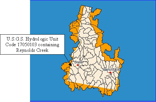
Click on link to download reach file version 3 and save to disk.
The resulting 17050103_rf3.exe is a self extracting zip file that contains
the 3 files comprising the shape file.
Digital Elevation model.
From USGS
(http://edcwww.cr.usgs.gov/doc/edchome/ndcdb/ndcdb.html). Click
on 1:24,000 DEM then FTP via Graphics. Click on the map to zoom in.
Click on individual map units desired.
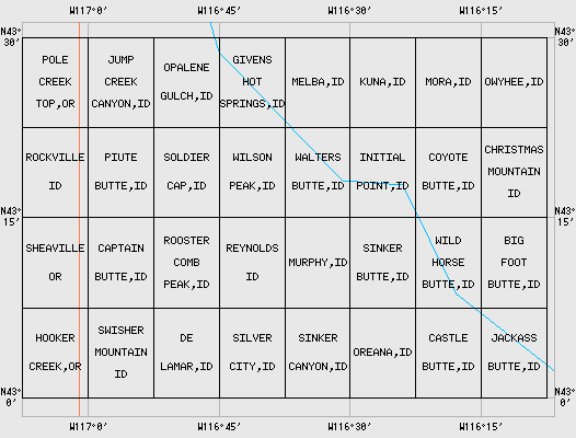
Reynolds Creek Watershed is encompassed by Soldier Cap, Wilson Peak,
Rooster Comb, Reynolds, De Lamar and Silver City. Download the zip
file for each. Uncompress. Use SDTS
DEM to ArcView Grid Conversion Utility (http://hydrology.usu.edu/dtarb/SDTSext.html)
to import these in to ArcView. Use Grid Merge script included with
SINMAP
(http://hydrology.usu.edu/dtarb/sinmap.htm) to merge
into a single DEM. Fill any gaps at boundaries by averaging.
Then the resulting file was Exported as ASCII.
Reynolds Creek Precipitation Data and Watershed outline.
This was obtained from the Northwest
Watershed Research Center (http://ars-boi.ars.pn.usbr.gov/index.html)
during collaborative research. It is not available online.