Utah Water Research Laboratory
Department of Civil and Environmental Engineering
Utah State University
Logan, UT 84322
U.S.A
Status
This public distribution of ArcET is "AS IS" without any claim of suitability or functionality for any purpose. ArcET was developed in 2003 for ArcGIS 8.3, but we have been unable to make the changes necessary to get it to work properly for ArcGIS 9.x. The ArcGIS 9.x ArcET source code from our attempt to get it to work for ArcGIS9.x is made available in case you want to attempt to use it, but at USU we do not have funds to assist with, support or upgrade ArcET. Shujun Li, the graduate student who wrote ArcET has graduated. He may be contacted at shujunli<at symbol>yahoo.com.
Background
In the United States, the US Geological Survey (USGS) is required by Federal mandate to estimate and report on water use for each state at five-year intervals. Because of the infrequent sampling interval and high-level aggregation, the utility of these data is limited with respect to identifying trends and supporting water demand forecasts for planning and decision-making. It might be more helpful and desirable to acquire water use patterns over a variety of spatial and temporal scales as well as forecast on future water need.
It is also worth noting that USGS has traditionally used a variety of inventory and census-type approaches to compile water use data through the cooperation from other federal, state, and local sources. While these approaches are effective for some categories like public water supply, it is hard to get systematic data on irrigation water use. Therefore to get sufficient and scientific irrigation water use data within the hydrologic system of interest, a more reliable and efficient methodology has to be developed to estimate this category of water use indirectly.
A water use estimation project undertaken by Utah Water Research Laboratory (UWRL) developed a GIS-based methodology for statewide water use estimation consistent with USGS water use categories using readily available electronic data from different sources with good spatial and temporal coverage. As part of this research project, a software package (an ArcGIS extension) was initially developed for the automation of the calculation of spatially distributed evapotranspiration, the core component of irrigation water consumption, from ground-based weather data and land use/cover information. We named this software ArcET though its functionality has been extended later for estimating crop irrgation water requirements.
Overview
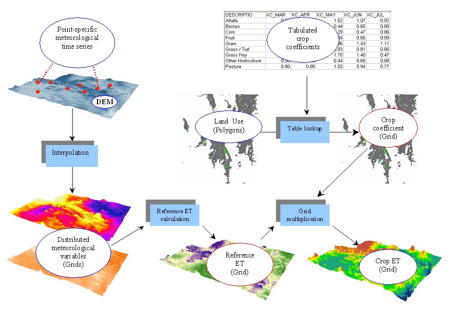
The conceptual Framework of the GIS-based approach for regional ET modeling is given in figure 1. The goal is to calculate crop evapotranspiration for every grid cell within the domain of a given study area. Inputs consist of time series of point meteorological data, land cover/land use data and crop coefficient tables. The meteorological data is interpolated to grids using interpolation procedures appropriate for the quantity being interpolated. These are then used to compute a grid of reference ET. The crop coefficient tables are used to provide a crop coefficient at each grid cell based upon land cover/land use data. Combining the crop coefficient with reference ET provides the estimated ET at each grid cell following the conventional Reference ET - Crop coefficients method.

Figure 1. The illustration of the proposed GIS-based approach for regional ET modeling
(Those box-style nodes in above figure symbolize predefined function modules )
Above framework was programmed in Microsoft Visual Basic, with GIS-related functionality coded through reference to ESRI ArcObjects. It was finally packaged as a dynamic link library (DLL) that can be easily customized into the main interface of ArcMap according to the standard procedure provided by ESRI.
Features
- Seamless integration of ArcGIS with spatially distributed ET modeling as an ArcGIS extension
- Friendly interfaces require less expertise in GIS and ET modeling
- Up to 6 built-in methods for calculation of reference ET
- FAO 56 Penman-Monteith
- Standardized ASCE Penman-Monteith equation for short grass
- Standardized ASCE Penman-Monteith equation for tall grass
- SCS modified Blaney-Criddle equation
- Hargreaves 1985
- Priestley-Taylor
Users do not need to worry about being restricted by data availability of one particular reference calculation method, users from any region can apply this extension for their work based on their data availability and regional climate & terrain conditions.
Outputs can be provided as visual GIS maps or/and commonly used database files.
Inputs & Outputs
For calculation of potential crop ET only, users are required to input the following data:- A data table providing time-series of meteorological variables
- An ESRI shapefile that gives the location of climate stations
- Digital Elevation Model (DEM) of the area of interest in ESRI GRID format
- An ESRI polygon shapefile for land use information
- A DBF table with crop coefficients for each crop type
- A polygon shapefile defining the areas where water use will be calculated.
A key field that uniquely identifies water use polygons needs to be selected.
- PRISM monthly precipitation GRID (only required for some precipitation options and controlled on the Precipitation Interpolation tab)
- Information about the irrigation efficiency (only required for generating irrigation efficiency map)
- monthly reference ET maps
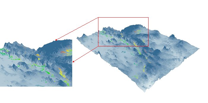
- monthly crop ET maps (Figure 2)
- monthly precipitation maps
- monthly crop irrigation water requirement maps
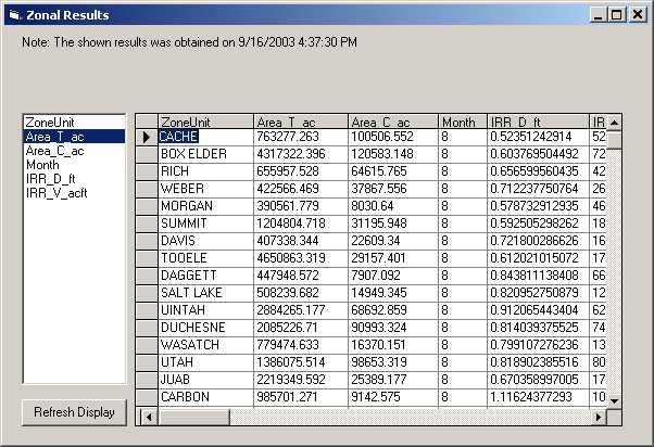
- tabulated monthly ET, irrigation water requirement information estimated for user-specified aggregation level (Figure 3)

Figure 2. Output as GIS map

Figure 3. Output in table format
For more information about ArcET, please see the ArcET User's Manual