
Creates 2 grids. The first contains the flow direction from each grid cell to one of its adjacent or diagonal neighbors, calculated using the direction of steepest descent. The second contain the slope, as evaluated in the direction of steepest descent, and is reported as drop/distance, i.e. tan of the angle. Flow direction is reported as "no data" for any grid cell adjacent to the edge of the DEM domain, or adjacent to a "no data" value in the DEM. In flat areas, flow directions are assigned away from higher ground and towards lower ground using the method of Garbrecht and Martz (1997). The D8 flow direction algorithm may be applied to a DEM that has not had its pits filled, but it will then result in "no data" values for flow direction and slope at the lowest point of each pit.
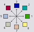
D8 Flow Direction Coding: 1 - East, 2 - Northeast, 3 - North, 4 - Northwest , 5 - West, 6 - Southwest, 7 - South, 8 - Southeast.
| Parameter | Explanation | Data Type | |
|---|---|---|---|
| Input_Pit_Filled_Elevation_Grid__must_be__tif_ |
Dialog Reference A grid of elevation values. This is usually the output of the "Pit Remove" tool, in which case it is elevations with pits removed. Pits are low elevation areas in digital elevation models (DEMs) that are completely surrounded by higher terrain. They are generally taken to be artifacts of the digitation process that interfere with the processing of flow across DEMs. So they are removed by raising their elevation to the point where they just drain off the domain. This step is not essential if you have reason to believe that the pits in your DEM are real. This step can be circumvented by copying the raw DEM source data onto the file with suffix "fel" to simulate the output of "Pit Remove" without actually removing the pits. Also, if a few pits actually exist and so should not be removed, while at the same time others are believed to be artifacts that need to be removed, the actual pits should have "no data" elevation values inserted at their lowest point. "No data" values serve to define edges of the domain in the flow field, and elevations are only raised to where flow is off an edge, so an internal "no data" value will stop a pit from being removed, if necessary. |
Raster Layer (Must be TIFF File) | |
| Input_Number_of_Processes |
Dialog Reference The number of stripes that the domain will be divided into and the number of MPI parallel processes that will be spawned to evaluate each of the stripes. |
Long | |
| Output_D8_Flow_Direction_Grid__must_be__tif_ |
Dialog Reference A grid of D8 flow directions which are defined, for each cell, as the direction of the one of its eight adjacent or diagonal neighbors with the steepest downward slope.
Flow Direction Coding: 1 -East, 2 - Northeast, 3 - North, 4 - Northwest, 5 - West, 6 - Southwest, 7 - South, 8 - Southeast. The flow direction routing across flat areas is performed according to the method described by Garbrecht, J. and L. W. Martz, (1997), "The Assignment of Drainage Direction Over Flat Surfaces in Raster Digital Elevation Models," Journal of Hydrology, 193: 204-213. |
Raster Dataset | |
| Output_D8_Slope_Grid__must_be__tif_ |
Dialog Reference
|
Raster Dataset |