
Assigns a flow direction based on the D-infinity flow method using the steepest slope of a triangular facet (Tarboton, 1997, "A New Method for the Determination of Flow Directions and Contributing Areas in Grid Digital Elevation Models," Water Resources Research, 33(2): 309-319). Flow direction is defined as steepest downward slope on planar triangular facets on a block centered grid. Flow direction is encoded as an angle in radians counter-clockwise from east as a continuous (floating point) quantity between 0 and 2 pi. The flow direction angle is determined as the direction of the steepest downward slope on the eight triangular facets formed in a 3 x 3 grid cell window centered on the grid cell of interest. The resulting flow in a grid is then usually interpreted as being proportioned between the two neighboring cells that define the triangular facet with the steepest downward slope.
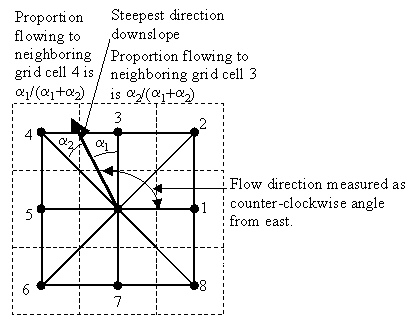
A block-centered representation is used with each elevation value taken to represent the elevation of the center of the corresponding grid cell. Eight planar triangular facets are formed between each grid cell and its eight neighbors. Each of these has a downslope vector which when drawn outwards from the center may be at an angle that lies within or outside the 45 degree (pi/4 radian) angle range of the facet at the center point. If the slope vector angle is within the facet angle, it represents the steepest flow direction on that facet. If the slope vector angle is outside a facet, the steepest flow direction associated with that facet is taken along the steepest edge. The slope and flow direction associated with the grid cell is taken as the magnitude and direction of the steepest downslope vector from all eight facets. Slope is measured as drop/distance, i.e. tan of the slope angle.
In the case where no slope vectors are positive (downslope), the flow direction is set using the method of Garbrecht and Martz (1997) for the determination of flow across flat areas. This makes flat areas drain away from high ground and towards low ground. The flow path grid to enforce drainage along existing streams is an optional input, and if used, takes precedence over elevations for the setting of flow directions.
The D-infinity flow direction algorithm may be applied to a DEM that has not had its pits filled, but it will then result in "no data" values for the D-infinity flow direction and slope associated with the lowest point of the pit.
| Parameter | Explanation | Data Type |
|---|---|---|
| Input_Pit_FIlled_Elevation_Grid__must_be__tif_ |
Dialog Reference A grid of elevation values. This is usually the output of the "Pit Remove" tool, in which case it is elevations with pits removed. Pits are low elevation areas in digital elevation models (DEMs) that are completely surrounded by higher terrain. They are generally taken to be artifacts of the digitation process that interfere with the processing of flow across DEMs. So they are removed by raising their elevation to the point where they just drain off the domain. This step is not essential if you have reason to believe that the pits in your DEM are real and can be circumvented using the raw DEM as input here. Also, if a few pits actually exist and so should not be removed, while at the same time others are believed to be artifacts that need to be removed, the actual pits should have "no data" elevation values inserted at their lowest point. "No data" values serve to define edges of the domain in the flow field, and elevations are only raised to where flow is off an edge, so an internal "no data" value will stop a pit from being removed, if necessary. |
Raster Layer (Must be TIFF File) |
| Input_Number_of_Processes |
Dialog Reference The number of stripes that the domain will be divided into and the number of MPI parallel processes that will be spawned to evaluate each of the stripes. |
Long |
| Output_D-Infinity_Flow_Direction_Grid__must_be__tif_ |
Dialog Reference A grid of flow directions based on the D-infinity flow method using the steepest slope of a triangular facet (Tarboton, 1997, "A New Method for the Determination of Flow Directions and Contributing Areas in Grid Digital Elevation Models," Water Resources Research, 33(2): 309-319). Flow direction is determined as the direction of the steepest downward slope on the 8 triangular facets of a 3 x 3 block centered grid. Flow direction is encoded as an angle in radians, counter-clockwise from east as a continuous (floating point) quantity between 0 and 2 pi. The resulting flow in a grid is then usually interpreted as being proportioned between the two neighboring cells that define the triangular facet with the steepest downward slope.
|
Raster Dataset |
| Output_D-Infinity_Slope_Grid__must_be__tif_ |
Dialog Reference A grid of slope evaluated using the D-infinity method described in Tarboton, D. G., (1997), "A New Method for the Determination of Flow Directions and Contributing Areas in Grid Digital Elevation Models," Water Resources Research, 33(2): 309-319. This is the steepest outwards slope on one of eight triangular facets centered at each grid cell, measured as drop/distance, i.e. tan of the slope angle. |
Raster Dataset |